Sexy seeds in the Seychelles

The largest seed of any plant in the world is the nut from the coco de mer palm tree, which is found only in the Seychelles. It is a protected species and only rarely are specially certified nuts available for sale, much to Laurel’s disappointment because the meat is said to have a unique and intriguing taste. We never saw a real nut for sale but every gift shop in the country is filled with replicas. Not because of their rarity, size or taste, but because the two lobes of the nut come together in a shape that is reminiscent of a woman’s crotch. A feature that is even more exaggerated in the souvenirs and novelties.

We encountered the real tree in a botanical garden in Victoria, the capital of the Seychelles, which is on the island of Mahe. When we stumbled across the tree, we didn’t realize it was a coco de mer at first but were immediately impressed by the size of its nuts.

The Seychelles is made up of dozens of islands spread across several groups. Earlier we visited the Aldabra Group of the country. Mahe is part of the granitic islands. Granitic was a new word for us but just means they are made of granite, as opposed to the coral sand of the atolls like Aldabra. The granitic islands hold the vast majority of the population, which isn’t vast. Victoria which is sometimes described as the “smallest capital city in the world” or sometimes “one of the smallest.” La Digue is another one of the granitic islands we visited, a sleepy tourist destination with its granite displayed to great effect at a much-photographed beach called Anse Source d’Argent.

We also visited the island of Praslin where we had some good snorkeling among the granite boulders and saw a shape-shifting octopus (in the middle of this video). On Silhouette Island we enjoyed a lazy afternoon watching crabs go about their business on the beach. If you would like to enjoy the relaxing pastime of crab watching, try this or this video.

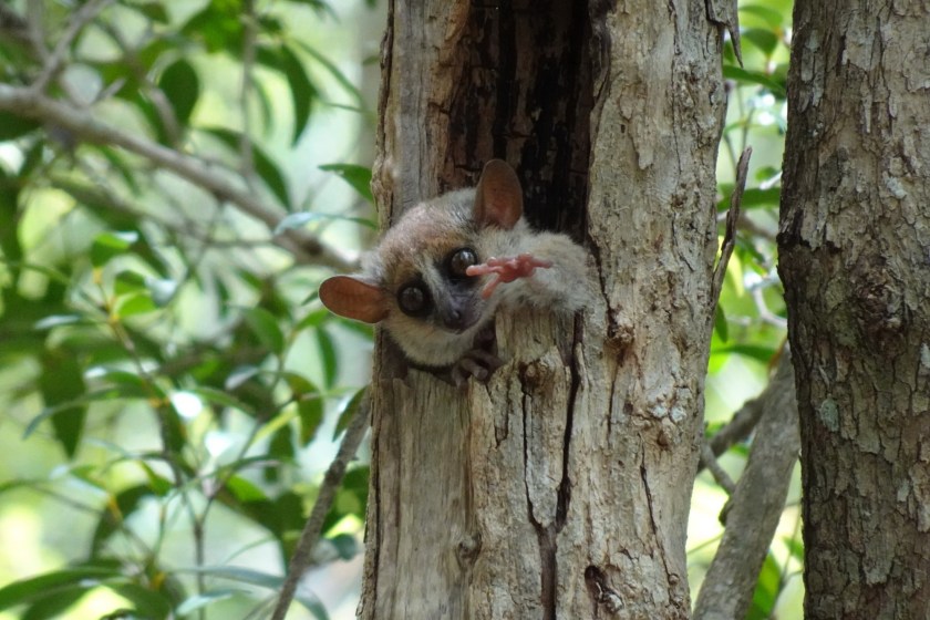
Below are our other highlights from the granitic islands.

Mauritius: unexceptional, in a good way

On our first visit to the island country of Mauritius in 2011, we just hung out at a beach resort while we recovered from the epic jetlag of flying to pretty much the exact opposite spot on the globe from Seattle. Mauritius “is known for its beaches” as Google says, so that was a fine first date but this time we wanted to get to know the country better, exploring its capital and countryside.

Like its closest neighbors Reunion and the Seychelles, Mauritius is a melting pot of cultures but with the strongest influence from the descendants of Indians who came to work the sugar cane fields 100-200 years ago. Colorful Hindu temples dot the island. One we visited was popular with a troop of photogenic monkeys who made-off with the offerings of fruit that worshipers left on the altars.

The sugar fields are still active and we spent a few hours at an interesting museum dedicated to sugar production and its big role in the history of the country. But Mauritius is now branching out economically well beyond sugar and the sugar-white beaches. It has a history of good governance that has made it a financial, logistical and corporate hub for Africa and the Indian Ocean counties. Modern (or in some cases ultra-modern) highrise bank headquarters have sprung up around the capital of Port Louis, mixing with the old colonial-era buildings and modest lowrise shops. Though there is a glitzy new shopping area on the waterfront (where the store clerks outnumber the sparse customers 4-to-1), Port Louis mostly has the feel of a true middle-ground between a rich western country and a poor country in Africa or South Asia. It is a little grimy and rundown, but also bustling and seems like the rising tide is helping the many, not just the few. It even has safe drinking water! Or so we heard, though Laurel might have gotten a mild stomach bug from eating the local street-food delicacy Dholl Puri, which was OK but definitely not tasty enough to be worth the trouble. Click here of a video of a busy street scene near the farmers market, in one of the less modern parts of downtown.

We visited a few art galleries around the island and enjoyed the work, especially the bold tropical visions of a successful local painter named Vaco who had a pet giant Aldabra tortoise named George. The most common motif seen in Mauritian art, culture and commerce is the flightless dodo bird, adopted as a symbol of the island despite it’s sad claim to fame as one of the most visible man-made extinctions.

One of the headline attractions on the interior of the island is a place called The Seven Colored Earth. In guide book photos, you see rolling hills of various shades of brown, purple, red and orange. When we arrived, the whole thing was much smaller than our expectations, a patch of bare eroded mud that you can circumnavigate on foot in two minutes. Charitably, it was maybe four shades of reddish brown. Without the build-up (and the hour long drive) we probably would have come away thinking “that was kind of interesting and pretty.” Instead it was a bit of a letdown but you can definitely take some nice photos of it from the right angle. Hopefully no one sees a pretty picture like the one below and decides they have to visit Mauritius to see this eighth wonder of the world.

Overall we enjoyed our explorations and found Mauritius a pleasant place. Easy to get around, safe, no hassles, decent infrastructure (except for the traffic jams), and pretty scenery. Maybe it didn’t have the WOW views of Reunion or the more unique cultural and wildlife experiences we had on Madagascar and Aldabra, but overall it was a perfectly serviceable tropical paradise. :-)

Is Reunion the most beautiful island in the world?

We are suckers for lush green islands with pointy mountains. Our jaws were perpetually dropped while on São Miguel Island in the Azores last year, and we’ve been struck in the past by Nuku Hiva in French Polynesia and St. Lucia in the Caribbean. But Reunion Island, a 39-mile-long spec of France in the Indian Ocean, may be tops (so far) in our book. Can cliffs get any steeper? Can you pack any more waterfalls into one viewpoint? Can you wedge any more vegetation into a valley?

Reunion is a volcanic island that rose up from a hot-spot under the earth’s crust. The hot-spot has moved relative to the earth’s surface over millions of years, leaving a chain of islands that stretch from India south to Reunion. Reunion is the newest member of the chain and still volcanically active, just like the Big Island is the newest and most active island in the Hawaiian chain. Its recent birth accounts for the dramatic topography and it is home to one of the most active volcanoes on earth, Piton de la Fournaise. It was quiet the day we visited but erupted as recently as last fall. We had to check it out. Because of the fresh lava and cinders, the volcano is the one part of the island that isn’t green. Instead you have a starkly beautiful moonscape, or maybe a Mars-scape since many of the iron-rich rocks have weathered into shades of red.

Reunion is a surprisingly cosmopolitan place. It packs in almost a million people throughout its many mountains and valleys. Like its neighbors Mauritius and Seychelles, Reunion was uninhabited until the arrival of Europeans a few hundred years ago and today the population is very ethnically mixed with people whose ancestors hail from Africa, Madagascar, Indian, China and Europe. It is an integral part of France and even had yellow vest protesters occupying a roadside park. Reunion has good infrastructure, including an offshore highway currently under construction that is said to be the most expensive road in the world by some measurement. We didn’t get a chance to see much of the capital Saint-Denis since we were so busy gawking at the mountains but we did have a pleasant morning at a Sunday market in an outlying beach town. We could have mistaken the farm tables, food carts and pyramids of artisanal condiments for a Seattle neighborhood market if it weren’t for the tropical fruits. Those who weren’t at the market were at big family picnics nestled in the trees by the beach. A giant storm was just an hour away, but the barbecues went on seemingly unconcerned.

150,000 giant tortoises

Aldabra Atoll is inhabited by a dozen researchers and about 150,000 giant tortoises that each weigh several hundred pounds and live for well over 100 years (the tortoises, that is, the researchers were all young and slim). If you’re not familiar with an atoll, it is a ring of reef and low-lying islands surrounding a central lagoon, formed after a long extinct volcano in the center eroded to nothing over millions of years.

Nearby Cosmoledo Atoll, showing the typical ring of low lying islands. Aldabra is too big to fit in one picture like this.

Giant tortoises used to live in warm areas around the globe but were hunted to extinction by humans everywhere but in the extremely isolated islands of the Galapagos and Aldabra. Even there, the tortoises were at risk after their discovery by Europeans because they can stay alive for months without food or water and were thus a useful source of fresh meat on long voyages. Aldabra is now a protected World Heritage Site and the tortoises are secure and doing well.

I’m doing well, thanks for asking.

Aldabra is governed by the Seychelles but far from the main inhabited islands that make up the rest of the country. It can only be reached by boat. Due to its remote location and permitting process required to visit it, only 20 or so tourist boats will come this year, up from zero a few years ago when the island was in a no-go area because of Somali pirates. But the staff on the island was very receptive to tourists, perhaps because the foundation that protects the island is funded in part by private donors so they like the good PR. They even had a little gift shop, where Laurel bought an official Aldabra t-shirt and coffee mug. We landed at the research station and were greeted right away by a giant tortoise. Then another, and another. We are used to long searches to get fleeting glimpses of the exciting rare wildlife of a particular location, but Aldabra is teaming with the giants. They are roaming around the cottages in the station, parked along the path into the forest, pretty much everywhere you look, chomping grass like cows.

Aldabra is also known for its sea life, being a marine protected area as well. Regrettably, the wind and waves were rough during our visit, so we were unable to snorkel. Aldabra Atoll itself is the largest of a group of four islands, collectively the Aldabra Group. We were able to snorkel at two of the other islands in the group, Assumption and Cosmoledo, but the continuing rough seas limited what we could see.

The Aldabra Group is coincidentally a hot-bed of activity for another giant shelled reptile, sea turtles. In a brief land visit to Assumption Island, we found fresh tracks from nesting sea turtles every several paces down the beach. Notice our footprints for scale next to the tracks below.

Finally, a few videos from the Aldabra Group:

  • The tortoises spend 99% of their time munching grass. Perhaps it isn’t very exciting in the usual sense but it is hypnotic and relaxing to watch these prehistoric creatures go about their business.
  • Here is a tortoise in action, racing past.
  • Cruising the lagoon of Adlabra at sunset, while the birds come home to roost.
  • We had a chance to snorkel with a couple flapping stingrays, all of us being pulled along by a strong current.

A lemur on your arm and a chameleon on your head

There are many highfalutin reasons why we love to travel, including experiencing nature and cultures that haven’t (yet) been wiped out or turned into a zoo-like setting for gawking tourists. Who’d want to see that? Well…sometimes us :-) The small island of Nosy Komba is a popular day trip from the resorts on Nosy Be. You get there on a small motor boat, landing at a cute beach town that seems to still have a small fishing industry but is mostly geared to tourists. Local guides lead you into the jungle to see the “wild” life (more on that in a minute) but not before passing dozens of gift shops along the way. Much of the offerings were good quality local handicrafts like embroideries, carvings, paintings and baskets.

Once you run the gauntlet of beckoning shopkeepers, you have your first wildlife sighting – a group of guys with a selfie-ready chameleon. Ethically dubious but it is fun see a chameleon so close up and get an opportunity to touch one. Turns out their stubby little fingers have sharp claws! Tip from Laurel to any chameleon fanciers: don’t put them on your bare skin. Tip from Brian: they don’t hurt at all when you put them on your hat, but they do get antsy after a few seconds and leap off.

Then the guide pulls out a boa constrictor you can wrap around your neck and a shy baby turtle. Luckily not at the same time. We briefly played with both and then moved on to see the promised headline act – lemurs. Our guide reaches into his bag and pulls out…bananas! Thankfully, the lemurs are not in the bag and are roaming free in the forest. But they know that if they hang around the trail, some nice people will show up with bananas. The guide smears banana in your hand and you wait while the lemurs hop from tree to tree, edging closer to your outstretched hand. These lemurs were not as tame as the rescued pet lemurs that we met on Lemur Island in 2011, still being a little leery of these banana-handed tourists. Eventually they take the bait and jump on your arm to eat the banana, the guide all the while trying to smear on more banana to keep them interested. The whole thing was definitely unseemly but a lot of fun.

After our lemur-high wore off, we walked back down the trail and checked out the shops. We bought a colorful straw beach bag and filled it with tropical fruit, conveniently using the last pennies of our Madagascar currency. So long Madagascar!

Nosying around the islands of Madagascar

First, an embarrassing admission. We noticed when planning our 2011 trip to Madagascar that some place names started with the word “Nosy” such as a beach resort popular with Europeans called Nosy Be. We had no idea what the word meant but found it endlessly amusing to say. On this trip, it wasn’t until after we visited a few places that were all named Nosy This or Nosy That that we finally learned that nosy means “island” in Malagasy. All those Nosy places were islands, a pattern that it probably wouldn’t have taken Sherlock Holmes eight years to deduce.

Madagascar itself is an island, but it doesn’t feel that way when you are on it. It is bigger than California and Washington combined. When you are inland, you can drive for hours in any direction without seeing the ocean. Heck, it look us over a week to drive half the length of island in 2011, though we were slowed by bad roads and distracted by lemurs. So the locals don’t think of the “mainland” of Madagascar as a island. But the northern part of Madagascar is surrounded by many little Nosys, most with beautiful white sand beaches, impressive rocky cliffs and rich coral reefs.

One of the many islands in Nosy Hara National Park

And don’t forget the land-based wildlife. On Nosy Tanikely, we found our first chameleons of the trip. Playing a bit second-fiddle to lemurs, chameleons are the other signature animal of Madagascar. When most people think of chameleons, they think of a lizard that uses its powers of color changing to blend in with its background. But in Madagascar, many of the chameleons are brightly colored and change hues to communicate their emotions. (Yes, chameleons have feelings too…) This guy below was gorgeous perhaps due to his excitement of having his picture taken.

A Panther Chameleon on Nosy Tanikely

The day after visiting Nosy Tanikely, we went to Nosy Hara National Park. We had a great snorkel there and combed the remote beaches. Here are some pictures from both areas:

Baobabs and Lemurs

The prime tourist draw on the central west coast of Madagascar is “The Avenue of the Baobabs.” The baobab tree grows in Africa and Australia also, but Madagascar is the hotbed of baobab excitement, home to 6 of the 9 species. Baobabs have thick trunks filled with spongy fibrous wood that can store water through long dry seasons. The stored water is also useful for humans – we often saw holes cut in their trunks where people had tapped the water over the centuries for drinking water.

The Avenue of the Baobabs. Those trees are really tall but it is a bit hard to see with the perspective.

A large baobab is centuries oldThey only grow a tiny amount each year in the harsh climate. We saw 10 year old “seedlings” that could have auditioned for the role of Charlie Brown’s Christmas Tree. Most of the trees you see pictured below are several hundred years old, some over a thousand years. While it looks like the trees were planted along the Avenue, the trees were there long before and the road built between them.

(Note that we’ve changed a bit how the photo galleries work compared to the last posts. From now on, the picture captions won’t appear until you click the thumbnail. That way the text doesn’t obscure the photo).

The baobabs were pretty, otherworldly and impressive but it was so hot there (over 100 degrees) that we didn’t stay long. And we were itching to get through the Avenue to our next destination, Kirindy Forest Reserve, where we hoped to see wild lemurs. Lemurs have traditionally been referred to as “the most primitive primates” but I don’t know if modern evolutionary biologists would be so judgmental. More scientifically, we’d call them “the most cute primates.” They only live in Madagascar (and a few nearby islands) and come in several shapes and sizes – filling many of the ecological niches occupied by other mammals elsewhere.

It was a two hour drive to reach Kirindy, down one of the roughest roads we’ve been on — deeply pot-holed and partially flooded by recent rains. A jeep ahead of us got stuck in the mud but our driver somehow maneuvered his way through the muck and we got quite a workout bracing ourselves against the bumps and lurches. But in the end we were well rewarded, seeing many lemurs of different species, quite close up. Including the elusive tiny “mouse lemur” which is normally nocturnal but for some reason decided to put on a sleepy little show for us.

We’ve also taken video on the trip but haven’t figured out how to embed them in the blog like the photos. When you click on a video, it will take you away from our page and you’ll have to use your browser’s back-button to return here. For your additional time-wasting pleasure we have:

  • Driving down the street in Morondava, the main town in west-central Madagascar, showing all the activity along the way. You may notice a lot of orange t-shirts. We arrived just after a presidential election and many people were wearing the t-shirts given out free by the eventual winning candidate.
  • Here’s a video to give you a nauseating taste of the rough road to Kirindy.
  • You may feel like you’ve filled your lemur quota for the day, but you haven’t seen the definition of cute until you click on this video of our sleepy mouse lemur.
  • These rough-housing sifakas (that’s what the white lemurs are called) are pretty adorable too.

The Desert Southwest…of Madagascar

We spent three weeks in Madagascar in 2011 and it was one of our favorite trips ever. From our standpoint, it had it all: friendly people, beautiful scenery, temperate weather and approachable charismatic wildlife. We rarely return to a destination but Madagascar seemed like it deserved a sequel. If you’ve seen the sequel to the movie Madagascar, you know that a sequel is never as good as the original but can still bring a smile of recognition and few new surprises as well.

This time we came during the rainy season, so rather than visiting the interior highlands which have the lemur-rich rainforests and picturesque rice terraces, we spent our time along the east coast. Shielded from the rain by the highlands, it is very dry with unique spiny vegetation and people who make their living from the sea. We started in the south and worked our way up the coast (more about the more northerly parts in future posts).

The favorite place we visited in the in the southwest was the little fishing village of Andavadoaka. It rarely gets tourists so we enjoyed one of our favorite travel experiences, a mutual exchange of happiness and curiosity.

The main city of the southwest is known as Tulear or Toliara. Most cities in Madagascar have two names, one French-influenced and one more true to the Malagasy pronunciation. “Malagasy” is the word used to describe the language and people of Madagascar. According to the best genetic, linguistic and archaeological evidence, the language and the people came to the uninhabited island 1500 years ago, then mixed with Europeans and Africans in more recent centuries to produce the unique culture that exists on the island today.

But we digress, Tulear/Toliara was not a sleepy village like Andavadoaka but a bustling city that sees it share of tourists, with the associated proliferation of pushy gift shops, touts and beggars. It still had some charm and a lot of visual interest but not a place we’d say was our dream of Madagascar. Outside of town were some little nature reserves that showed off the resilient desert plants and wildlife, including salty Lake Tsimanampetsotsa (a prize to anyone who can pronounce that!) which boasts a resident population of flamingos.

Bunny Chow in Durban

The first stop on our Indian Ocean trip was Durban, South Africa. We took it easy for our couple days in town, mostly just getting over jetlag. But we did have one big goal — to eat Bunny Chow, a local food specialty. To make it, you hollow out a quarter loaf of bread and fill the hole with spicy curry. Our quest was satisfied in a mall food court.

The chef was a little embarrased that we wanted to take his picture with his creation.
It was surprisingly spicy and delicious (those are carrot shreds on top)

The spicing of the curry was very strong and reminiscent not only of Indian curries but also had hints of Ethiopian flavors. Speaking of which, it is traditional to eat your Bunny Chow with your hands. Our fingers were orange through several washings.

Here are some more images of Durban… mostly from shopping malls. But not just any old mall, the Gateway mall is the second largest in Africa (after one in Casablanca which we somehow missed). And we also went to uShaka, a mall/beach park.

The parts of Durban we saw were really lush and pretty. We’re told there are much grittier areas but we took some long drives and saw only leafy suburbs and glistening highrises. Both the upscale mall and the more populist beach park were encouragingly racially integrated, though with a disproportionately high number of white people at the mall and low percentage at the beach. We would have been more optimistic about the progress in the country if we hadn’t read just an article in The New Republic magazine on the long flight to Durban that described the problems of extreme economic and racial disparities in the country. And the resulting rise of demagogues, corruption and cynicism. The article made the case that South Africa is a leading indicator for the future of America.